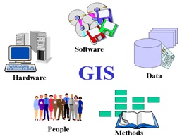
COMPONENTSOF A GIS
An operational GIS also has a series of components that combine to make the system work. These components are critical to a successful GIS.
Hardware
Hardware is the computer system on which a GIS operates. Today, GIS software runs on a wide range of hardware types, from centralized computer servers to desktop computers used in stand-alone or networked configurations
Software
GIS software provides the functions and tools needed to store, analyze, and display geographic information. A review of the key GIS software subsystems is provided above.
Data
Perhaps the most important component of a GIS is the data. Geographic data and related tabular data can be collected in-house, compiled to custom specifications and requirements, or occasionally purchased from a commercial data provider. A GIS can integrate spatial data with other existing data resources, often stored in a corporate DBMS. The integration of spatial data (often proprietary to the GIS software), and tabular data stored in a DBMS is a key functionality afforded by GIS.
People
GIS technology is of limited value without the people who manage the system and develop plans for applying it to real world problems. GIS users range from technical specialists who design and maintain the system to those who use it to help them perform their everyday work. The identification of GIS specialists versus end users is often critical to the proper implementation of GIS technology.
Methods
A successful GIS operates according to a well-designed implementation plan and business rules, which are the models and operating practices unique to each organization.
As in all organizations dealing with sophisticated technology, new tools can only be used effectively if they are properly integrated into the entire business strategy and operation. To do this properly requires not only the necessary investments in hardware and software, but also in the retraining and/or hiring of personnel to utilize the new technology in the proper organizational context. Failure to implement your GIS without regard for a proper organizational commitment will result in an unsuccessful system ! Many of the issues concerned with organizational commitment are described in Implementation Issues and Strategies.
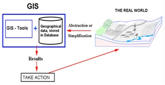
HOW A GIS WORKS
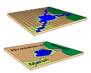
A GIS stores information about the world as a collection of thematic layers that can belinked together by geography. This simple but extremely powerful and versatile concepthas proven invaluable for solving many real-world problems from modeling globalatmospheric circulation, to predicting rural land use, and monitoring changes in
rainforest ecosystems.
Geographic information contains either an explicit geographic reference such as latitude and longitude or national grid coordinate, or an implicit reference such as anaddress, postal code, census tract name, forest stand identifier, or road name. Anautomated process called geocoding is used to create explicit geographic references
(Multiple locations) from implicit references (descriptions such as addresses). Thesegeographic references can then be used to locate features, such as a business or forest, and events, such as an earthquake, on the Earth's surface for analysis.
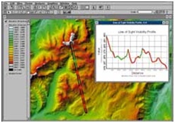
Transform the entire area with description and location
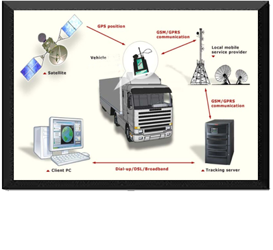
Connecting between location information and central geographical database
The component of geographical information system GIS
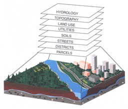
Converting land surface to multiple layers to work with it individually